
Tales Of The Unexpected, The West Kernow Way
Kernow is the name of the ancient Celtic Kingdom at the very south-western tip of England, nowadays better known as Cornwall. The West Kernow Way is a newly launched, largely off-road bikepacking route that takes you deep into Kernow’s ancient history, archaeological sites, old tin-mining settlements and fishing communities. The figure of eight route offers up a swashbuckling blend of lost ways, abandoned mining tracks, windswept beaches, clifftop gravel and remote moorlands. It packs a challenging 4,000 metres of climbing into 239 kilometres.

I’d heard about the West Kernow Way during lockdown. It’s existence sounded mythical; this was a route that may or may not have already existed depending on who you spoke to. Largely off-road, the West Kernow Way hugged the coast of the ancient Celtic kingdom at the other end of the UK. Cycling UK were planning to release an official route guide in the autumn and I scoured the internet trying to piece together the rumoured route before the crowds arrived. If it did already exist no one was giving any clues away, and my search to discover the route became something of an obsession but got me nowhere.
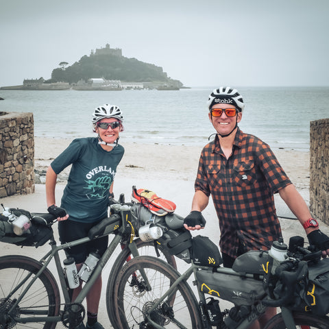
Let’s make one thing clear upfront. I don’t really have the cycling credentials to be the very first person to ride the West Kernow Way. I come to find myself on the startline because when we’re not riding our bikes for fun or doing our day jobs I am one of the founders of Stohk. Four cycling friends who pour our spare energies into making small batches of amazing pale ale in Bodmin, Cornwall. Our recipe was born out of a search to develop the perfect après-adventure beer, one to be enjoyed by anyone who shares in the spirit of being ‘out there’.
So when we heard that Cycling UK were about to launch the West Kernow Way just down the road from the brewery, we knew we had to be there at the start to ride the route and ‘get the beers in’. We were, well, literally stoked when cycling UK invited us along to ride the freshly launched route before anyone else.
 |
 |
Day 1
Field notes: We split our route into 3 but if you want to stop and enjoy the sites and sights consider splitting it into 4 days or more. Our first day was just under 100km including the section to the start at Penzance and then onto Porthleven. The first section of the ride is a mixture of quiet backlanes and bridle path around the coastline to St Just. There are various places to eat up until St Just. From this point you’ll be mainly off-road on lost ways and tracks away from civilization until the next feed stop St Erth. After this point it’s a mix of gravelly tracks and lanes down to Porthleven. Pack plenty of supplies as there are parts where you may need them!
 |
 |
As we roll off the promenade in Penzance I am buzzing with excitement. We had 100km to cover and a lot of off-road climbing ahead of us. It was time to get on with what we came here for - to be the first people to ride the new route.

The first section of Day 1 sees you down the coast to Lands End before you swing to the North. Things start to change pretty quickly after Lands End with stunning views around Cape Cornwall and towards St Just, a bustling little place which happens to also be the last outpost for supplies before you head ‘into the wild’.

My advice when tackling the West Kernow Way is eat and drink when you can or regret it later. As you head away from St Just it suddenly feels like you are leaving the modern world behind; in a way the last place on the route before you head deep into ancient Kernow. Things change very quickly. Roads are replaced with old mining tracks, villages are replaced with abandoned ancient settlements. We have just travelled back in time - it’s mind blowing.

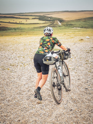
Before long you are in the middle of nowhere on the uplands of West Penwith. Following the Tinners Way, a prehistoric ridgeway track across rugged moorland I am in awe of this place. We pass cairns, ancient stone circles and burial sites and it truly feels like going back in time to another world. As I strain to push my bike up the rocky incline I realise that it must have been quite a journey in days gone by, even on horseback. Remounting my bike and getting the hang of the terrain I am glad of my choice of 38x11-44 gearing and in awe of how well my Condor Odyssey copes with what is full on MTB terrain. Parts of the WKW are pretty challenging on any kind of bike and perhaps none more so than parts of The Tinners Way but it’s worth every bit of it, for the epicness of the place and the wild ride down the other side.

As I concentrate hard on picking my way through moorland scrub, ruts and over the rocky steps on the old footpath trying hard to protect my rear mech, I hear a scream from behind and suddenly Jo is out of sight. I drop the bike and run back to find her lying on the track next to her bike. A first warning that you need to have your wits about you out here. I am sure some will prefer detours around this section, but for those who want the full Kernowfornia experience and a chance at some old world singletrack it’s unmissable.
 |
 |
Having pushed our way along parts of the Tinners Way, we realise our average speed had plummeted and we’ve lost over an hour. We were getting way behind schedule and I could feel I was eating into my energy reserves. “Should’ve had a pasty in St Just” I say to Jo. I am now getting worried we’re not going to make Porthleven before dark, and with no real idea what the route has in store next, we’re worried about what the WKW might dish up next. I suggest we check the map to see what it looks like, and see we have no phone signal. That’s another thing you need to be prepared for. We finally get a bit of signal to re-route, opting to cut a corner with a bit of road in a bid to regain some ground. By now we know that average speeds on West Kernow Way can be hard to predict so with over 20km to go we agree we’d better push on.
With the light waning fast we opt to quickly make camp before finding food. As we cycled around the restaurants in Porthleven enquiring for dinner, it slowly dawned on us that everywhere had stopped serving for the night.
 |
 |
Day 2
Field notes: For our second day we planned another 100km, to leave a short final morning ride and plenty of time for a swim in the sea. After a climb out of Porthleven you join the gravel coastal path for sections towards The Loe Bar. We take the short route pushing across the sand bar before the steep gravel climb on the other side. The next section of the route zig-zags across old footpaths with a National Trust cafe on the beach for last snacks before heading towards Mullion.
From Mullion it’s a rough section of old footpath across common ground down towards the Lizard before lots of undulating hills heading North. In the summer you can shortcut across the ferry at Helford if you fancy it. Gweek is a good food stop before heading north on a mixture of tracks and lanes towards Stithians and then onto the old mining trails that route you around Redruth to Portreath.
Next day we were woken early by the sound of seagulls but we both drifted back to sleep.
We had planned on 100km for day 2, thinking we’d have plenty of time but by the time we’d got breakfast it was almost 10:30. “Better get cracking” I thought.
It’s hard not to be uplifted by cycling along a coastal path. Joining the coastal path and flying down a smooth gravel section with a full stomach and the salty sea mist blowing into our faces, I was already feeling much better. Not heeding the signs to get off and walk, I gingerly made my way down to the beach, whilst Jo obediently dismounted. Following a couple of mountain bikers who looked like they knew where they were going, we headed down to The Loe Bar. I had heard about this place. A sort of ‘gravel bar’ separating the sea from what I figured was a brackish lake behind.

The weather was typically Cornish. The wind blew a grey damp humid sea mist into our faces as we started pushing our bikes through the soft gravelly sand. Just as I was thinking how nice it might be for a swim on a sunnier day, I remembered that the currents were apparently treacherous around here - there’s even a legend about ‘killer waves’ that come along once every 7 years.
The navigation gets a bit tricky on this section of the route and after a few wrong turns and a quick coffee at the National Trust Cafe we eventually found ourselves in the quiet hamlet of Mullion.
 |
 |
From Mullion you take a rough old bridle path before a welcome stretch of lane towards the farm at Predannack. It was at this point that things started to go downhill, figuratively and then literally. Up until this point we had fairly rigidly stuck to the official route. As we rolled through the farmyard, the farmer flagged us down. “You can’t go down there” he said. “It’s a footpath. Bikes aren’t allowed and in any case it’s not suitable for them”.
I explained a bit about the route, showed him the map and hoped he’d give us his blessing. Instead we got the potted history of the track and it’s use over the ages and alongside a multitude of other local ‘land’ issues that existed. It was kind of fascinating as he explained his ancestral history over generations farming the land and he eventually gave us permission to carry on, although it was clear he’d much rather we went back towards Mullion and to the north of the old airfield.
 |
 |
Glad to escape, we went through the gate and were immediately into another tough rocky uphill section. I could see what he meant as I was again thinking a horse would be a better steed. Annoyed about losing more time, the lack of food and sleep was also blunting my effort. Stopping for a moment to catch my breath I looked down to my food pouch where my GoPro had been living. It wasn’t there! My heart sank. It must have bounced off somewhere. When had I last seen it? Not since The Loe Bar. That was way back and all downhill. We were barely 20km into this section and already way behind but there was no way I was giving up the stories and footage I had captured without a fight. Almost 5km back we went, when suddenly a dog walker appeared out of nowhere. “Is this your GoPro?” he said. I was stunned - maybe Cornish fairies do exist I thought! Turned out the fairy was disguising as a local mountain biker who immediately started to impart wisdom and advice. He started to recount stories of parts of the section to the Lizard turning to a quagmire in the wet and on any day pretty challenging on a gravel bike in his opinion.
Mid afternoon, we were way behind schedule as I flew down the hill towards Gweek.

With a lot of ground still to cover and a heightened paranoia of missing dinner still we gobbled down our lunch of full fat coke, pasties and crisps and remounted the Condors. It wasn’t perhaps the best energy food but it tasted great!
The next section promised some decent mixed-terrain towards Stithians and we hoped to make up some lost ground before climbing Trewithen Moor. The roads in this part of Cornwall are amazing. They have a sort of glassy smooth, silvery finish you don’t often see in the UK. They’re a joy to ride on but sadly not as flat as we’d hoped. Constantly up and down frequently exceeding 10% until we went joined the flatter tracks around the reservoir before gradually gaining height towards the south of Cambourne and Redruth.
The riding around Redruth on the old mining tracks is single track gravel heaven and you could happily ride around here all day but we were on a mission to get to fresh fish dinner in Portreath via short detour through Redruth stuffing our Apidura musettes to capacity with protein and beer. We pulled up to a little campsite in Cambrose just up the road from Portreath. No time for hanging around though. Fish and chips were needed and just in the nick of time we grabbed a table inside moments before they pulled over the closed sign at 7:30pm. Who said there was plenty more fish in the sea?

Day 3
Field notes: The section is around 50km and a ‘Coast to Coast’ route following the spectacular mining trails in the north before heading across farming land and bridle trails towards the south. The climb up to Carn Brea is well worth the diversion to take it all in. With panoramic views you can survey much of the peninsula you have cycled around. Expect the unexpected though with constantly varied terrain and some sections where the path is actually a stream.

The last section of the route continued to dish out hills and hunger in equal measures. Still having not learnt our lesson we foolishly whisked past an open bakery on our way through Portreath and then a corner shop on the edge of Cambourne as we picked up the old mining trails. Hours later we’d regret this again realising that on a Sunday nothing was open.
The climb out of Portreath goes up what feels like an old funicular railway track, the sort that goes up very steep-sided cliffs! The Garmin tells me it’s over 15% - a rude awakening on the final day.
Kernow doesn’t let up. If the reward is sections of amazing scenery and riding, the price is the challenging terrain that often links it up. And depending on your point of view the bonus is the added ‘fun’ served up by various streams and muddy quagmires that have claimed the route. Full of confidence I charge at the first stream hoping to emerge like a rock star, before having a sinking feeling and resigning myself to wet feet. “At least it’s the last day” I think.
The sun had finally burnt through the mist, and as we passed through farmland on old bridle tracks for once the gradient had eased up and we had a bit of speed finally.

Just when I was getting into a rhythm on a rocky section on the side of a sloping hill, the Garmin indicated a sharp left upon the slope and I glanced ahead to a short ramp immediately in front. I could see it was steep and loose but I was committed now and made a split second decision to drop down a few clicks and attack it. Forgetting about the extra weight, I realised gravity was getting the better of me. Too late, too steep,“Tooo - ssslll - ooohhhhwww” I exclaimed.
Back on the bike all the excitement had made me hungry. A quick look at the OS Map on my phone confirmed the only possible chance of food would be if we detoured south on the road. We probably should have realised that in deepest Kernow, the chances of finding anywhere open on a Sunday were slim, but we coasted along the smooth road and enjoyed a few easy miles on another amazingly smooth road before accepting we were going to be hungry until Marazion. We headed back North to rejoin the route.
The final section was classic WKW - more tales of the unexpected. Re-crossing the route from day 1, we both stopped and surveyed an impenetrable mixture of brambles, bushes and trees that had grown up over the stream and was well over 10 foot high. There was no way through, but according to the map this was a bridle path along the side of the stream.

We thought about going back up the track and finding an alternative route but not wishing to be beaten, I set about finding a way through. Pushing our way alongside a hedgerow of brambles and nettles we carried our bikes down into a ditch across the stream wrestling them under the branches and then over a steep bank where we eventually made it through to the other side. “That was fun!” I sarcastically announced. But in a funny way it was. The rest of the ride was a cruise in comparison, and the pasty and cream tea at Marazion was the best I have ever tasted. And without the challenge of climbing through that ditch, riding through those streams, the berating by the farmer, falling off or even the long double back to find the GoPro the day before; it wouldn’t have tasted half as good.
The WKW still feels like work-in-progress due to some frustrating sections and in some senses feels like an unfinished masterpiece. As more people tackle it, I have no doubt the route will be refined and also hope the hospitality businesses take the opportunity to embrace the hungry cyclists that will come knocking.
The surprise of the WKW is not how amazing the place is but more the surprises around every corner. For now it remains a place still undiscovered and West Kernow very much unknown. But come here and you will discover it’s unexpected rawness and beguiling beauty. Fairy tales are guaranteed and you will no doubt come away with your own tales of the unexpected.
Field notes: The latest GPX file of the route will always be available on the Cycling UK website and aims to take into account all the most recent changes the charity has been made aware of, based on rider feedback and developments in the landscape. If you are going to ride the West Kernow Way, the charity suggests you download the latest GPX file from their website as it will be the most up to date file and should give the best experience of the wonders of Cornwall: https://www.cyclinguk.org/route/west-kernow-way-gpx-and-map
Best enjoyed after a 


 while sitting near a

